

Reading a plat map is about decoding a property's official story. You're looking for the hard lines—the legal boundaries, lot dimensions, easements, and public rights-of-way. Think of it as the definitive blueprint for a piece of land, showing exactly how a larger tract has been carved up into lots, blocks, and streets. For professionals, mastering this skill isn't just about understanding a property; it's about mitigating risk and uncovering opportunities efficiently.
What Is a Plat Map and Why Does It Matter?

A plat map isn't just a sketch; it's the official, recorded legal blueprint for a property or an entire subdivision. For anyone working in real estate, knowing how to interpret these documents is a non-negotiable skill. It’s what separates assumptions from hard facts and empowers you to analyze a property with confidence.
When you master reading plats, you can spot a property's true potential—and its hidden problems—long before they derail a deal. You get concrete answers, which is exactly what you need for thorough due diligence and solid client advice.
The Cornerstone of Due Diligence
Every single developer, title professional, and real estate agent leans on plat maps to get the ground truth. These documents are the key to answering critical client questions before anyone gets too far down the road. Flying blind without this info is just asking for costly, time-consuming mistakes.
A quick look at a plat map can confirm:
- Official Property Boundaries: Where a parcel of land actually begins and ends, not just where the fence is.
- Building and Use Restrictions: Any easements or setbacks that could kill plans for a new pool or a home addition.
- Legal Access: Whether the property has clear, undisputed access to a public road.
This skill has become even more essential as property records go digital. In the United States, we’ve seen a huge push toward digital parcel mapping. Since 2015, initiatives have expanded to include data on 3,229 counties nationwide, a massive undertaking. While this digitization makes information more accessible, it also means you need to be sharp enough to read what you find. Interestingly, only ten states have made these records totally free at the state level. You can learn more about the nationwide progress on parcel data over at regrid.com.
At the end of the day, a plat map isn’t just a drawing; it's a legally binding record. It's the foundation for the legal description, title insurance, and zoning approvals, making it one of the most powerful tools you have for mitigating risk and ensuring a smooth closing.
How to Find and Verify the Correct Plat Map
Before you can even begin to decipher a plat map, you have to get your hands on the right one. This is a bigger hurdle than most people think. A quick Google search can easily pull up unofficial copies or, worse, outdated versions that lead to massive headaches and costly mistakes.
The only document that matters is the official, legally recorded plat map. Your go-to source is always the local county government office—this could be the County Recorder, Clerk, or Register of Deeds, depending on where you are. Thankfully, most counties have moved their records online, which should always be your first stop.
Navigating County Records
Once you find the county’s website, you're looking for a portal labeled "Public Records Search," "Official Records," or something similar. You can't just type in a street address and hope for the best. To cut through the noise of thousands of documents, you need a specific piece of information. This is where a title commitment becomes your best friend.
Use one of these key identifiers from the commitment to zero in on the correct map:
- Legal Description: This is your most direct route. It will often name the subdivision, lot, and block numbers that point straight to the plat.
- Parcel Number (APN): While this number is assigned by the tax assessor, it's a unique identifier that can usually be cross-referenced to find all recorded documents for the property.
- Recording Information: Sometimes a title commitment will give you the exact "book and page" number where the plat is filed. It doesn't get much easier than that.
Getting this right is absolutely critical for any kind of due diligence. For instance, the specialized work done by landmen in the oil and gas industry hinges on this level of precision with historical records.
I’ve seen this happen countless times: someone confuses a simple survey sketch with a legally recorded plat map. A survey is just a snapshot in time for a specific purpose. The recorded plat is the foundational document that actually created the legal lots. Always, always prioritize the official plat.
Confirming You Have the Latest Version
Okay, so you found a plat map. You're not done yet. Now you have to confirm it's the most current version. Properties get re-platted all the time, and amendments can be filed that completely change boundaries, easements, or restrictions.
You need to actively look for notes on the map or in the chain of title that mention a "Replat," "Amended Plat," or "Vacation of Plat."
Ignoring these updates is a classic, and expensive, blunder. I've seen situations where someone relied on an old map, only to miss a newly dedicated utility easement that completely torpedoed their client's construction plans. You have to check for any subsequent recordings that affect the original plat. This ensures your analysis is grounded in the current legal reality of that piece of land.
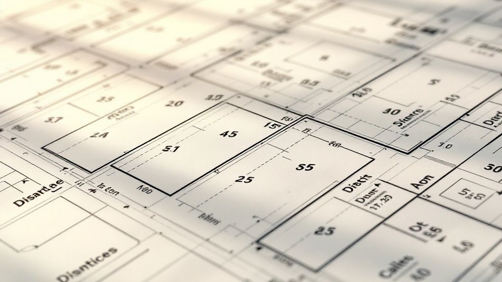
Breaking Down the Key Elements of a Plat Map
Once you have the official plat map in hand, the real work begins. Now you have to translate all those lines, symbols, and notes into something you can actually use. This is where you move past just identifying a piece of land and start to really understand its character, its limitations, and its potential.
Think of it like learning the specific vocabulary and grammar of a new language—every single element on that page tells part of the property's story.
This isn't a process you can rush with a quick glance. A plat map gives you a ton of visual information, from property boundaries and lot sizes to the all-important orientation. For example, in a place like Santa Clara County, California, the plat map that comes with a title report includes a compass arrow showing how the home is situated. That little detail can seriously impact property value based on things like sunlight exposure. You can see more real-world examples of what these maps reveal at SanJoseRealEstateLosGatosHomes.com.
Decoding the Map Legend and Scale
Your first stop on any plat should always be the map legend, or key. Seriously, don't skip this. This is your Rosetta Stone for the entire document, defining what every symbol, abbreviation, and line style actually means. You’ll find symbols for everything from utility easements and building setbacks to monuments and right-of-ways.
Next, find the scale. This tells you the ratio between measurements on the map and the actual distances on the ground (for example, 1" = 50'). Using the scale is absolutely critical for getting a rough idea of dimensions without ever setting foot on the property. It gives you a quick sense of the lot size, how wide the road is, or how much space a utility company can claim.
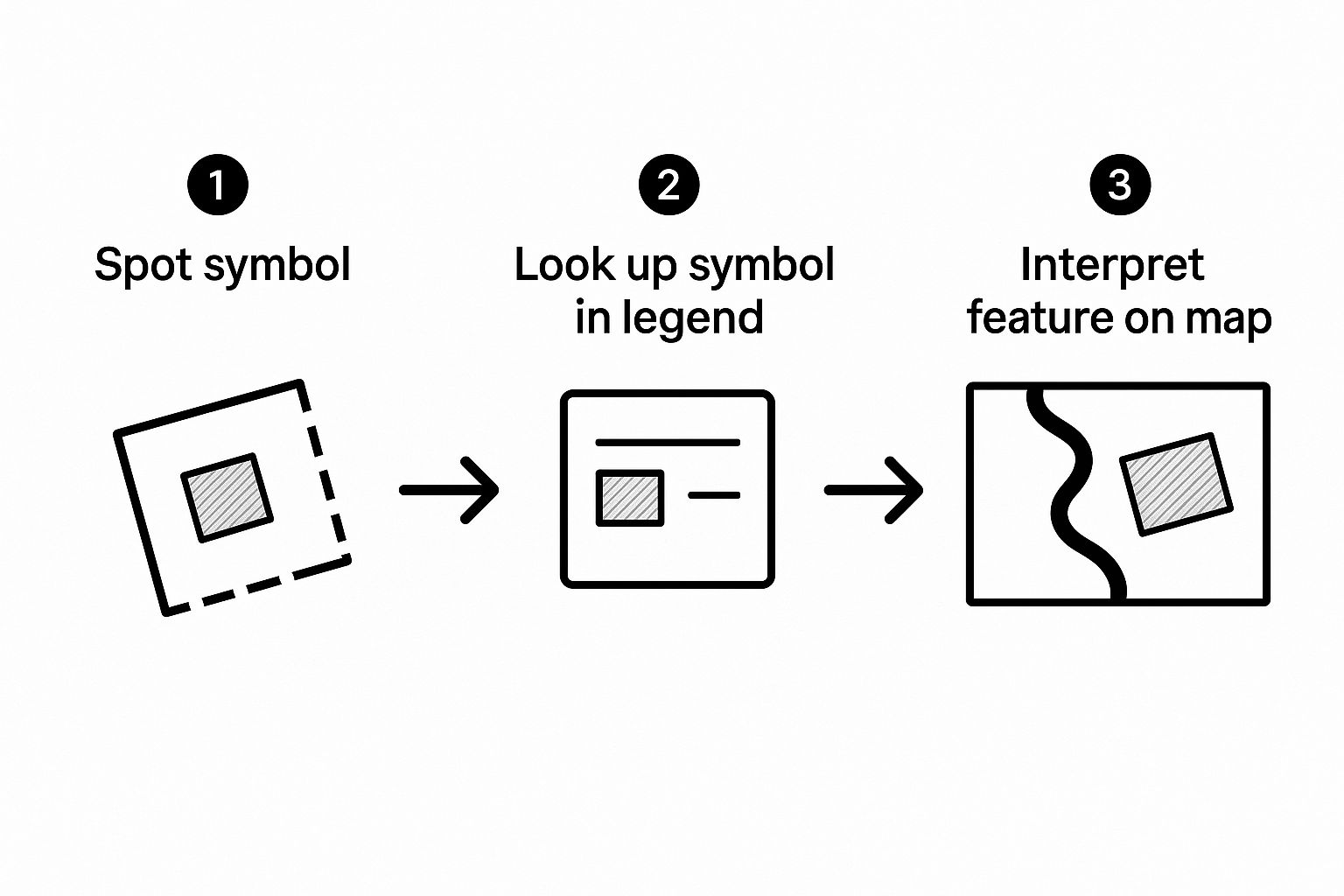
This simple three-step flow is a great reminder to never assume what a symbol means. Always, always check the legend to confirm its definition before applying that meaning to a specific spot on the map.
Understanding Boundaries and Orientation
The whole point of a plat is to define a property's exact boundaries. This is done using bearings and distances—the specific directions and lengths for each property line. A bearing might look something like "N 89°15'30" E" (North, 89 degrees, 15 minutes, 30 seconds East), and it'll be paired with a distance, like "150.00 ft".
When you put all these measurements together, they create what’s known as a "metes and bounds" description that forms a complete, closed shape. This is the legally recognized perimeter of the property.
You’ll also find a North arrow on every plat. This is an essential tool for orienting the map and understanding how the lots are situated in the real world. Does the backyard face south, getting sun all day? Is the front of the house facing a busy western street? The North arrow gives you the context to answer these practical questions.
I see this mistake all the time: people focus only on the main lot and completely ignore what's happening around it. You have to analyze the adjacent lots, the streets, and any noted easements. What your neighbor does can directly impact the property you're looking at.
Identifying Lots, Blocks, and Easements
Plat maps organize land into a logical grid of lots and blocks. Each individual parcel gets a lot number, and a group of those lots is usually contained within a larger block. This system makes legal descriptions so much simpler. Instead of a long, complicated metes and bounds description, a property can be identified as "Lot 5, Block B of the Sunnyvale Subdivision."
Finally—and this is arguably the most critical part—you have to identify any easements. These usually show up as dashed lines or shaded areas, and they grant specific rights to other parties to use a portion of the property.
Here are a few common ones you'll run into:
- Utility Easements (U.E.): Gives utility companies the right to install, access, and maintain their lines for things like water, sewer, electricity, or cable.
- Access Easements: Grants a neighbor the right to cross over the property to get to their own land. You see this a lot with shared driveways.
- Drainage Easements (D.E.): This ensures water can flow properly through a designated area. You usually can't build anything on it.
To help you get comfortable with these, here’s a quick-reference table for the symbols and abbreviations you’re most likely to see on a standard plat map.
Common Plat Map Symbols and What They Mean
| Symbol / Abbreviation | Full Name | Practical Meaning for a Property |
|---|---|---|
| P.O.B. | Point of Beginning | The starting and ending point for the property's legal boundary description. |
| U.E. | Utility Easement | An area where utility companies have the right of access. Building is usually restricted here. |
| D.E. | Drainage Easement | Land set aside for water runoff. Construction is prohibited to ensure proper drainage. |
| R/W | Right-of-Way | A strip of land, often for a road or path, that the public or a specific party can use. |
| B.L. | Building Line | A line showing how close to the property line you're legally allowed to build a structure. |
| (M) | Measured | Indicates that a dimension shown was physically measured, not just calculated. |
| (R) | Recorded / Record | Shows a dimension that comes from a previously recorded deed or plat, which may differ from a new survey. |
Familiarizing yourself with these is a huge step toward reading a plat map with confidence and spotting potential issues before they become real problems. Spotting a 20-foot utility easement that cuts right through the middle of a backyard is a total game-changer. That single detail could be what stops your client from building their dream pool. Recognizing these elements is absolutely vital for anyone involved in property development. In fact, our specialized tools for developers building complex projects are designed to automatically flag these very issues from title and plat documents, which saves an incredible amount of time and prevents extremely costly mistakes.
Connecting the Plat Map to the Title Commitment

A plat map by itself is just a picture. Its real value is unlocked when you hold it up against the property's title commitment. Think of them as two halves of the same story—one gives you the visual, the other gives you the legal and financial backstory. The real work, the actual due diligence, happens when you bring them together.
This isn't about just glancing at both documents. It's a line-by-line comparison to make sure the map's story perfectly aligns with the title report's. This meticulous process is your best defense against discovering a boundary dispute, an unrecorded easement, or a major title defect when it’s far too late.
Verifying the Legal Description
First things first: you have to cross-reference the legal description. The title commitment will spell it out in no uncertain terms, something like "Lot 10, Block C, of the Oakhaven Estates subdivision, as recorded in Plat Book 112, Page 45." Your job is to pull that exact plat map and confirm the property you care about is, in fact, Lot 10 in Block C.
It sounds almost too simple, but you'd be surprised how often tiny discrepancies signal huge problems. A typo in a lot number or a reference to an old, superseded plat could mean the entire title commitment is for the wrong piece of land. Getting this right is the foundation of everything else you do.
Let's take a real-world example. A developer is looking at a parcel described as "Lot 5." A quick look at the plat map shows Lot 5 has perfect road frontage—a key feature. But when they plot the metes and bounds description from the title commitment, it actually traces out the adjacent, landlocked parcel. That single check, that mismatch between the map and the commitment, just uncovered a deal-breaking title issue.
Mapping Title Exceptions to the Plat
Next up, turn your attention to Schedule B-II of the title commitment. This section lists the exceptions—all the rights and claims others have on the property that your title insurance policy won't cover. This is where you connect the legal jargon to a physical location on the map.
The commitment might list things like:
- A 15-foot utility easement along the northern property line.
- A shared access easement for the neighboring lot to use the driveway.
- Building setback lines that were recorded with the original subdivision covenants.
You need to find the visual proof of each exception on the plat. Look for the dashed lines marking that 15-foot utility easement. Find the shaded area showing the shared driveway. If the commitment mentions an easement but you can’t find it on the plat, that’s an immediate red flag that demands more digging.
This manual cross-referencing is where expertise truly shines, but it's also where human error can creep in. A missed exception or a misread boundary can have huge financial consequences. This is precisely the kind of detailed, repetitive work that is slow and difficult for people but perfect for automation.
Manually validating every single detail between these two dense documents is incredibly time-consuming. This is exactly why platforms like TitleTrackr were built—to automate this validation, comparing legal descriptions and mapping exceptions in seconds. For professionals like title abstractors who require precision and speed, this kind of technology transforms hours of manual work into an instant, accurate report. It ensures nothing gets lost in translation between the legal text and the visual map.
Spotting Red Flags and Advanced Plat Analysis
Once you've got the basics of reading a plat down and can line it up with the title commitment, it's time to go deeper. This is where you graduate from just reading a map to truly analyzing it, developing that expert eye for the subtle red flags and potential deal-breakers most people would walk right past.
It's all about being proactive. You’re using the plat as a crystal ball to spot problems before they blow up a deal and jeopardize a client's investment. This means looking beyond the simple boundaries and easements for the little clues that hint at much bigger headaches.
Common Issues Hidden in Plain Sight
Some of the gnarliest property issues are staring you right in the face on the plat—if you know what to look for. Training your eye to catch these early can save an unbelievable amount of time and money later.
You absolutely have to be on the lookout for these common red flags:
- Landlocked Parcels: This is a big one. If the property on the plat doesn't physically touch a dedicated public right-of-way or have a clearly defined, recorded access easement, it could be legally landlocked. That’s a potential nightmare.
- Ambiguous Shared Driveways: A plat might show a driveway crossing property lines, which looks fine on paper. But without a corresponding recorded easement document, its use isn't legally guaranteed. You're basically looking at a future neighbor dispute just waiting to happen.
- Encroachments: This happens all the time. When you compare the plat to a recent survey, you might see a neighbor’s fence, shed, or even part of their garage crossing over your client's property line.
- "Paper Streets": This is a classic issue with older plats. They often show streets that were planned out but never actually built. A property whose only access is a "paper street" has a massive access problem.
Building a Complete Risk Profile with GIS
To really understand a property's risk, you can't just rely on the plat alone. You have to start layering on more information, and that's where modern mapping tools become your best friend. By overlaying plat data with other key information, you build a complete picture that no single document ever could.
For instance, keep an eye out for contour lines on a plat map. These wavy lines show changes in elevation and can immediately flag potential drainage problems or hidden construction costs from a steep slope. A tight bundle of contour lines right where a client wants to build a deck might mean their dream project is actually an engineering nightmare.
Think of a plat map as a single, crucial layer of your due diligence. True expertise comes from stacking that layer with other data points—like flood zones, topography, and zoning restrictions—to see the full, multidimensional story of the property.
Modern Global Information Systems (GIS) and mapping software have completely changed the game here. Specialized tools can merge parcel boundaries from a plat with detailed terrain data, opening the door for advanced analysis. You can run calculations for cut-and-fill volumes for new construction or delineate watersheds for environmental reports.
This tech gives you a much deeper understanding of the land itself. You can see what's possible with modern mapping software over at Blue Marble Geographics.
Trying to do this level of deep analysis by hand is possible, but honestly, it's incredibly inefficient. Purpose-built software is designed to handle this complexity with far greater speed and accuracy. It flags potential conflicts automatically, giving you the insights to advise your clients with real confidence. This is how you move from just reading a plat to performing a comprehensive, risk-averse property analysis.
Got Questions About Plat Maps? We’ve Got Answers.
Once you’ve got the hang of the basics, you start running into those tricky real-world situations. These are the head-scratchers and common points of confusion that I see trip up even seasoned pros from time to time.
Getting these details straight is what separates a good read from a great one. Let's tackle some of the most frequent questions that pop up when you're deep in the weeds with a plat map.
What Is the Difference Between a Plat Map and a Survey?
This is probably the most common question, and the distinction is critical.
Think of a plat map as the official, master blueprint for an entire neighborhood or subdivision. It’s the legal instrument that carves out individual lots, blocks, and streets from a much larger piece of land. Its whole purpose is to show how that bigger parcel was legally divided.
A survey, on the other hand, is a very specific snapshot of one single property. It’s drawn by a surveyor who goes out to the property and physically locates the boundary lines, buildings, fences, and any other structures on that lot right now.
Here’s a simple way I remember it: a plat is prescriptive—it prescribes how the land is divided. A survey is descriptive—it describes what's actually there on the ground today. Both are essential, but they serve completely different legal roles.
Can a Plat Map Be Outdated or Incorrect?
Absolutely. And assuming a plat is perfect is a risk you just can't afford to take.
Older plats can be a minefield of outdated information. You might find they don't show recent lot line adjustments, vacated easements that are no longer valid, or even entire re-subdivisions that have occurred since the original map was filed. On top of that, the original document itself might just contain a flat-out error.
This is why you always have to do your due diligence:
- Pull the latest recorded version of the plat directly from the county recorder’s office. Don't rely on an old copy you found somewhere else.
- Compare it, line by line, with the current title commitment.
- If anything looks fishy or doesn't add up, the only real answer is to order a new ALTA/NSPS Land Title Survey to get a definitive picture of what’s happening on the ground.
Why Does the Plat Map Acreage Differ from the Tax Records?
This one causes so much confusion, but the answer is pretty straightforward. Tax assessor records are built for one main purpose: property valuation for tax collection. They aren't meant to define legal boundaries.
Assessors often use estimates, old data, or simplified calculations to arrive at an acreage. It's close enough for their purposes, but it’s not legally binding.
The recorded plat map and the legal description are the documents that hold up in court. They define the property's true size and dimensions. If you ever see a conflict between the tax records and the plat, the plat and survey data always win. No exceptions.
How Do I Confirm Property Access from a Plat Map?
A plat map is your first and best tool for verifying legal access. You need to scan the map for a dedicated public right-of-way—like a street or a road—that physically touches the boundary of the lot you’re looking at.
What if it doesn't? Your next step is to hunt for a recorded access easement. This will show up on the map as a clearly marked strip of land that gives the lot owner the legal right to cross a neighbor's property to get to a public road.
If you can't find either of those, you're looking at a "landlocked" property. That's a massive red flag that craters the land's value and makes it incredibly difficult to use or develop.
Jumping between plats, surveys, and title commitments is tedious and leaves the door wide open for mistakes. TitleTrackr uses AI to automate this grind, pulling the critical data you need and flagging discrepancies in seconds. Stop chasing paper and start finding answers.

Leave a comment