

When you first lay eyes on a plat map, it can feel intimidating. You’re looking at a sea of lines, numbers, and strange symbols that don't immediately click. It's easy to feel like you're trying to decipher a secret code, and the manual effort required to analyze it can be a significant drain on your time.
But that document is one of the most fundamental legal records tied to a piece of property. For industry professionals, learning how to read it efficiently isn't just a useful skill—it's essential for making informed, profitable decisions in real estate, land management, and title examination.
Your First Look at a Plat Map
So, what exactly is this document? Think of a plat map as the official blueprint for a subdivision or commercial development. It’s a highly detailed diagram, drawn to scale, that shows how a large tract of land is carved up into individual lots, streets, and common areas. It's not just a sketch; it's a legally binding document filed with your local county or municipal authority.
Essentially, it’s the master plan that brings order to the chaos of land development.
What Is the Purpose of a Plat Map?
The main job of a plat map is to create a crystal-clear, official record of property boundaries. Before a developer can sell individual lots in a new neighborhood, they must hire a licensed surveyor to create this map. It then gets scrutinized by local government agencies to ensure everything aligns with zoning laws and planning standards.
Once it's approved and officially recorded, the plat map becomes the go-to reference for several critical functions:
- Defining legal lot boundaries for every single parcel.
- Establishing public and private streets and any rights-of-way.
- Identifying easements, which are areas reserved for things like utilities, drainage, or access.
- Creating a simplified legal description for each lot (like "Lot 5, Block B of the Sunnyvale Subdivision"), which is then used in deeds and title paperwork.
This whole process gives us a standardized, reliable way to describe and transfer property. It’s a system with deep roots, dating back to the Public Land Survey System (PLSS) established in 1785. The PLSS introduced the grid system of townships and sections that is still fundamental to land ownership in much of the United States. You can explore more about the history of plat books to see how they’ve evolved.
A plat map transforms a raw piece of land into a collection of precisely defined, legally recognized properties. It's the foundational document that makes modern real estate transactions possible, providing certainty for buyers, sellers, and lenders.
Without this official map, we’d be stuck with vague property descriptions, leading to constant boundary disputes and significant legal headaches.
Once you understand its core purpose, that intimidating sheet of paper starts to look less like a confusing diagram and more like a powerful tool. It gives you an authoritative overview of a property’s dimensions, its exact location, and any legal strings attached. Mastering this is where all serious property analysis begins, setting you up to analyze any piece of land with confidence.
Interpreting Essential Plat Map Symbols
Every plat map is a dense visual document, communicating crucial information through a specialized language of lines, symbols, and abbreviations. If you can't speak this language, you're flying blind. A simple dashed line could be misinterpreted, and that kind of mistake can lead to incredibly costly errors in development or real estate deals.

This is your practical guide to decoding those elements. We're moving past the basics to give you a real, working knowledge of what to look for and how to interpret it correctly.
Locating Your Key Navigational Tools
Before you dive into individual lot lines, you need to get your bearings. Think of these foundational components as your map's navigational aids. Ignoring them is like trying to read a book without knowing the alphabet.
- The Legend or Key: This is your primary decoder. It’s a dedicated box that tells you exactly what each symbol, line type, and abbreviation on the map means. It should always be the first place you look.
- The North Arrow: It’s a simple but vital symbol. The north arrow establishes the map's orientation, and all property lines and directional bearings are relative to it.
- The Scale: Usually shown as a ratio like 1” = 100’, the scale is how you translate distances on the map into real-world measurements. This is absolutely critical for verifying lot dimensions or calculating setbacks.
- Surveyor’s Notes: This section provides crucial context. You'll often find the survey date, the basis for bearings, and descriptions of any physical markers (like iron pins) used to mark property corners.
These elements provide the framework for everything else on the map. You can't even begin to understand the dimensions of a parcel without first checking the scale.
Distinguishing Between Different Types of Lines
On a plat map, not all lines are created equal. Their style—whether they are solid, dashed, or dotted—carries specific legal weight. Misreading a line type is one of the most common and expensive mistakes people make when learning to do this.
A solid line almost universally represents a property boundary or lot line. This is the legally defined edge of a parcel of land. You can think of it as the property's definitive perimeter.
On the other hand, a dashed or dotted line usually signifies something that exists within a property but doesn't define its boundary. Most often, this is used to show an easement, which grants a third party (like a utility company) the right to use that specific portion of the land.
A solid property line tells you where your ownership begins and ends. A dashed easement line alerts you to where someone else’s rights might limit how you can use the property you own. That distinction is fundamental.
For instance, a dashed line running across your backyard might indicate a drainage easement. That means you can't build a permanent structure like a shed or a pool in that area. Understanding this simple difference is the key to avoiding violations that could force you to tear down a structure. The sheer complexity of tracking these details manually is why professionals turn to platforms like TitleTrackr, which can quickly surface and organize this kind of critical data, preventing costly oversights.
Decoding Common Abbreviations and Notations
Surveyors use a standardized set of abbreviations to save space and keep maps from getting too cluttered. While the legend should define most of them, getting familiar with the common ones will drastically speed up your analysis.
It helps to have a quick reference guide. Think of this as a cheat sheet for deciphering the shorthand you’ll see on nearly every plat map.
Common Plat Map Symbols and Their Meanings
| Symbol / Abbreviation | Meaning | Why It's Important |
|---|---|---|
| R/W | Right-of-Way | Indicates land reserved for streets, sidewalks, or public access, restricting private use. |
| P.O.B. | Point of Beginning | The starting point for a property's legal "metes and bounds" description. |
| I.P. or I.R. | Iron Pin or Iron Rod | Denotes a physical survey monument placed at a property corner. |
| P.U.E. | Public Utility Easement | Specifies an area where utility companies have the right to install and maintain their lines. |
Let’s say you see "P.U.E." marked along the front 10 feet of a lot. This tells you immediately that utility providers have a legal right to access that strip of land to work on power, water, or gas lines, even though it's technically part of the private property.
Having this knowledge from the start prevents potential conflicts and ensures you're aware of all legal encumbrances before they become a problem.
Reading the Fine Print: Legal Descriptions and Boundaries
The symbols and lines on a plat map are just the visual guide. The real power—the legal authority—lies in the legal descriptions. This is the text that officially defines a property's size and location, and it's the absolute foundation of ownership. If you're in real estate or land development, getting comfortable with these descriptions isn't just a good idea; it's a non-negotiable part of due diligence.
You'll mainly run into two types: 'Lot and Block' and 'Metes and Bounds'. They each have their place, and figuring out which one you're looking at is the first step.
The Simplicity of Lot and Block Descriptions
In planned subdivisions, the Lot and Block system is king. It’s a beautifully simple shorthand that uses the recorded plat map as its reference point. You'll see something like this: "Lot 12, Block C, of the Oakhaven Estates subdivision, as recorded in Plat Book 115, Page 42 of the County Recorder's Office."
The description itself is a direct pointer. It tells you exactly where to find the official map that has all the detailed survey work laid out. Your job is to pull up Plat Book 115, flip to page 42, and find Block C. Lot 12 will be right there. All the boundary lines, dimensions, and easements are already drawn out for you. It's an incredibly clean and efficient system for built-out neighborhoods.
This diagram breaks down the basic flow for finding your parcel on the map.
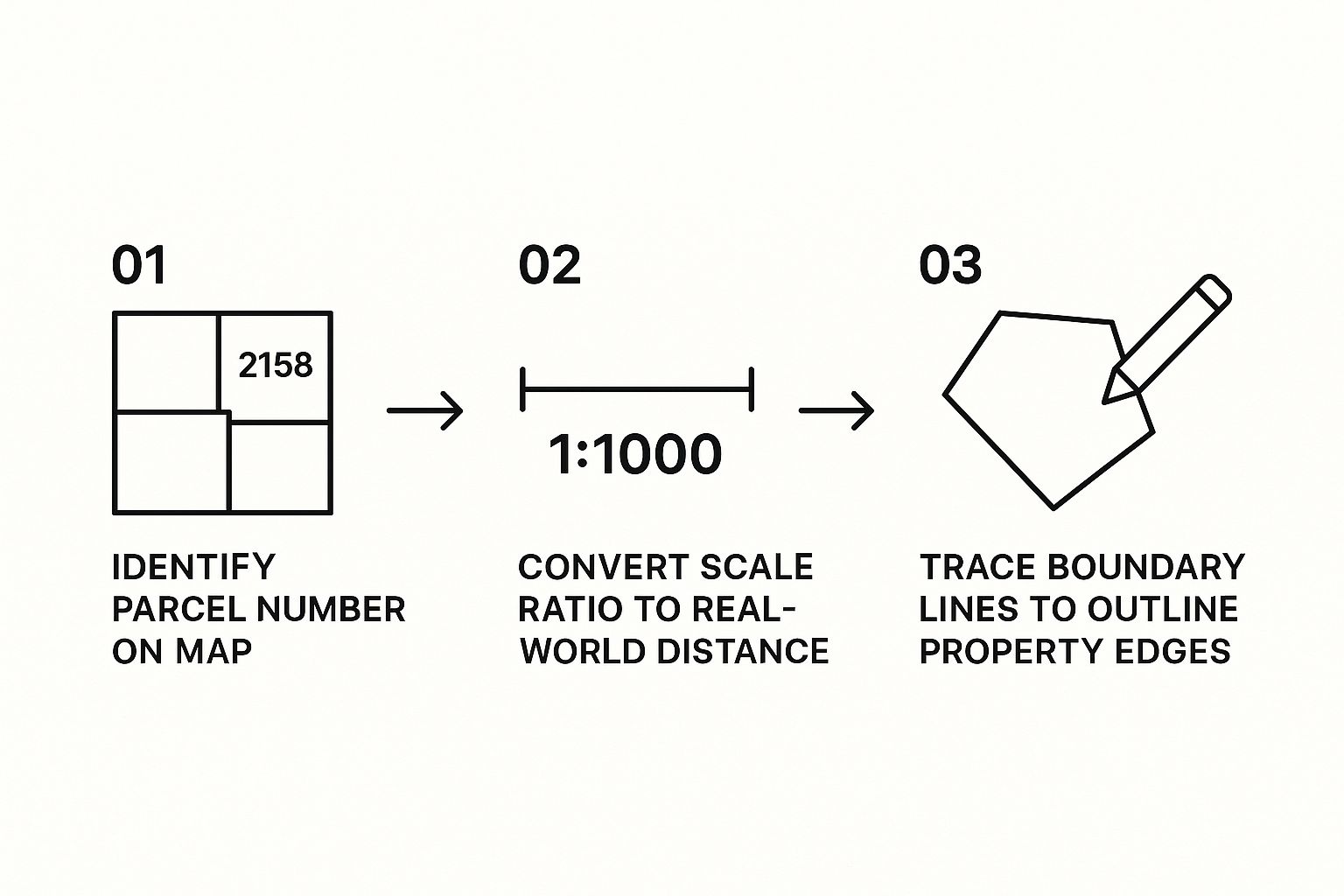
As you can see, it boils down to identifying the parcel number, using the scale, and tracing the boundaries. These are the fundamental skills for outlining any property on a plat.
Decoding the Complexity of Metes and Bounds
When you move outside of formal subdivisions or deal with oddly shaped parcels, things get more complex. You'll likely encounter a Metes and Bounds description. This method is a whole different beast. It describes the property's perimeter by essentially giving you walking directions from a specific starting point, using precise directions and distances.
This is where knowing some old-school surveyor terminology becomes crucial:
- Point of Beginning (P.O.B.): This is the fixed, identifiable starting line for the entire description. Everything is measured from this spot.
- Monuments: These are physical markers—either natural, like an old oak tree, or man-made, like an iron pin—that serve as the property's corners.
- Bearings and Distances: This is the heart of the description. A line might read "N 45° 15' 30" E, 150.00 feet." That translates to: face North, turn 45 degrees, 15 minutes, and 30 seconds toward the East, and then travel for 150 feet.
Think of a Metes and Bounds description as a narrative journey around the property's edge. Each call of direction and distance is a single step on that path. If you misinterpret just one call, the entire shape of the property gets distorted.
To trace these out, you have to follow each call from one monument to the next with meticulous care until you loop all the way back to the Point of Beginning.
Handling Curves and Arcs
Of course, property lines aren't always straight. For subdivisions with cul-de-sacs or winding roads, the plat map will include specific curve data. Reading this requires a few more terms:
- Radius (R): The distance from the curve's center point to the property line.
- Arc Length (A or L): The actual distance you'd walk along the curved boundary.
- Delta (Δ): The central angle of the curve.
Picture a lot at the end of a cul-de-sac. Its front boundary isn't a straight line; it's an arc. The plat map gives you the exact radius and arc length needed to trace that curved section of the property perfectly.
Getting a handle on these descriptions is fundamental. It’s how you confirm lot sizes and spot potential encroachments. For title professionals, the precision required is immense. It’s why so many experienced real estate abstractors now lean on specialized software to cross-reference this data, catching potential mistakes that could be missed by the naked eye.
Ultimately, fluency in legal descriptions is what separates a novice from an expert when it comes to reading a plat map.
Finding Hidden Restrictions Like Easements
Some of the most expensive mistakes in property analysis are born from what you don't see at first glance on a plat map. Beyond the clean property lines, you'll often find legally binding restrictions—specifically easements and rights-of-way—that can completely change a property’s value and how it can be used.
Ignoring these can be a disaster. Just imagine your team has plans drawn up for a major development, only to find out a utility easement runs right through the spot where a key structure was supposed to go.
Differentiating Easements from Rights-of-Way
People often use these terms interchangeably, but they have very different legal meanings. An easement gives a specific party the right to use a piece of someone else's land for a very particular purpose. It's a right to use, not to own.
A right-of-way (R/W), on the other hand, is a specific type of easement that grants the right to pass over another person's land. Think roads, public walking paths, or even railroad tracks.
You need to know which kind of easement you're dealing with, because their impact varies wildly:
- Utility Easement: The most common one you'll see. It lets utility companies (power, water, gas, cable) get onto the property to install and service their lines. You'll usually find these running along the front or back edges of a lot, marked with dashed lines and an abbreviation like "P.U.E."
- Access Easement: This gives a neighbor the right to cross your property to get to their own. It’s common for landlocked parcels that don't have direct road access.
- Drainage Easement: This one is all about water flow. It ensures water can drain properly off a property or through a subdivision. You are strictly forbidden from building anything that blocks this flow.
A Real-World Cautionary Tale
A commercial developer once bought a huge tract of land for a multi-million dollar retail center. The plat map had a small drainage easement mentioned in the surveyor's notes, but it wasn't drawn prominently. The plans were drafted and approved with a major anchor store sitting right on top of this restricted area.
Right before breaking ground, a final title search caught the conflict. That discovery forced a complete redesign of the site plan, delaying the project by six months and costing over $250,000 in new architectural fees, permit changes, and carrying costs. A single overlooked note nearly killed the entire development.
An easement is more than just a line on a map; it's a legal encumbrance that can dictate what you can and cannot do with your own land. A meticulous review for these restrictions is absolutely non-negotiable for any serious property transaction.
How to Spot Easements on a Plat Map
Finding these restrictions takes a sharp eye and a systematic approach. First, find the map's legend. This is your key, defining all the different line types and symbols used. As I mentioned, dashed or dotted lines are the classic visual cue for an easement.
From there, scan the entire perimeter of the lot and pay close attention to any unusual lines or notations. Look for abbreviations like "U.E." or "D.E." And don't just look at the drawing—read every single one of the surveyor's notes. This is where critical details are often hiding.
The grunt work involved in finding every potential restriction across piles of documents is a huge drain on time and resources. This is especially true for landmen, who must guarantee clear access and rights before any drilling or development can happen. That challenge is precisely why many are turning to solutions that can automate this painstaking work, like those offered by TitleTrackr for landmen, to make sure no crucial detail is ever missed.
How Technology Is Changing Plat Map Analysis for Good
Traditional map-reading skills are still vital. But if you're relying solely on manual methods in today's market, you're operating at a serious competitive disadvantage. Technology has completely changed the game for plat map analysis, pulling the industry out of dusty record rooms and onto powerful, interactive digital platforms.
This isn't just about making things easier; it's about unlocking layers of insight that were nearly impossible to obtain efficiently before.
From Paper to Pixels: The Rise of Digital Mapping
For decades, the only way to read a plat map was to physically drive to a county recorder's office, unroll massive paper documents, and painstakingly trace the information you needed by hand. It worked, but it was slow, inefficient, and wide open to human error.
The real shift began in the mid-20th century. Between 1960 and 1975, huge leaps in data storage and computing power gave birth to modern Geographic Information Systems (GIS). This was the turning point, marking the beginning of the end for static paper maps and the rise of dynamic digital ones. You can discover more insights about the history of GIS and see just how far we've come.
The Power of Layered Data with GIS
GIS is the engine that drives a much deeper, more sophisticated analysis of plat maps. Instead of staring at a single, flat document, GIS lets you overlay multiple layers of critical data right on top of a base plat map. Suddenly, you have a complete, multi-dimensional view of a property.
Think about it. A real estate developer can now:
- Layer on zoning codes to instantly see if a parcel is approved for specific uses.
- Overlay FEMA flood zone maps to get a quick handle on environmental risks.
- Bring in utility infrastructure data to pinpoint the exact location of water mains and power lines.
- Add environmental reports to check for potential contamination issues.
This ability to stack information gives you a level of context a paper map could never provide. You can spot conflicts, uncover opportunities, and make smarter decisions without spending days chasing down documents from a half-dozen different agencies.
Technology transforms a plat map from a simple boundary drawing into a rich, interactive database. It allows you to ask complex questions and get immediate answers about a property's potential and its limitations.
Automating the Toughest Parts of the Job
While GIS offers incredible visualization, the biggest breakthrough for industry professionals has been in data extraction and automation. Anyone who's tried to find and interpret plat maps across thousands of different counties knows the pain. Each has its own quirky filing system and unique document format, making the process an absolute grind.
This is where AI-driven platforms like TitleTrackr create a massive efficiency gain. These tools are built to automate the most painstaking parts of the job—searching countless public records, pulling out the necessary information, and organizing it all into a clean, usable format.
This screenshot from TitleTrackr gives you a glimpse of what that looks like: a clean, centralized dashboard for managing all your property data.

The platform takes incredibly complex property information and consolidates it, making it easy to access and analyze without a single minute of manual data entry. Instead of burning hundreds of hours on research, you get accurate results in a fraction of the time. This lets you stop collecting data and start analyzing it.
Got Questions About Plat Maps? We've Got Answers.
Even after you’ve gotten the hang of the symbols and legal descriptions, real-world questions always pop up right when you're deep in a project. Let's be honest, learning to read a plat map is an ongoing skill, and some of the trickier situations can stump even seasoned pros.
Here, we'll tackle the most common points of confusion with clear, straightforward answers to help you navigate these documents like you've been doing it for years.
What’s the Difference Between a Plat Map and a Survey?
This is easily one of the most frequent questions we hear, and the distinction is absolutely critical. While they’re related, they serve completely different functions.
Think of a plat map as the master plan for an entire subdivision. It's the big-picture, legally recorded document that shows how a huge tract of land gets sliced up into individual lots, streets, and common areas. Its main job is to lay out the legal framework for the whole development.
A property survey, on the other hand, zooms in on one specific parcel. It’s a highly detailed drawing of a single lot, showing precise boundary lines, the exact location of buildings, and any physical issues like a neighbor's shed creeping over the line. A surveyor creates this after taking boots-on-the-ground measurements.
In short: The plat map is the blueprint for the neighborhood. The survey is the measured-out, detailed diagram of your specific yard.
How Can I Find the Official Plat Map for a Property?
Getting your hands on the official, recorded plat map is step one for any real property analysis. The old-school method is to head down to the County Recorder's, Clerk's, or Assessor's Office where the property is located.
Many counties have tried to modernize by putting these records online. But if you've ever used one of these portals, you know they can be clunky and often assume you already have a key piece of information, like a parcel number or the exact plat book and page number. If the map hasn't been digitized—which is common for older records—you're stuck making a trip to the county office.
This whole manual process of digging through different county databases is a massive time sink, especially for professionals who work across multiple jurisdictions. It’s exactly this headache that platforms like TitleTrackr were designed to eliminate. By pulling data from thousands of counties into one simple, searchable interface, you get instant access without all the legwork.
Why Are Some Older Plat Maps So Hard to Read?
If you've ever squinted at a historical property record, you know the feeling. Trying to decipher a faded, decades-old plat map can be incredibly frustrating. There are a few reasons why.
- They Were Drawn by Hand: Many older maps are works of art, meticulously hand-drawn by a surveyor. But that also means you're trying to read someone's unique handwriting, and the precision just can't match modern digital standards.
- The Slow Fade of Time: Imagine a document being photocopied, then scanned, then photocopied again over 50 or 100 years. The quality degrades severely. Lines get blurry, text becomes a smudge, and crucial details just vanish.
- A Lack of Standardization: Back in the day, the rules for what had to be on a plat map varied wildly from county to county. This means you're constantly having to re-learn how to interpret a map depending on where the property is.
This inconsistency is a major pain point. It's also where modern data extraction tools shine, as they can normalize the information and pull the key details into a consistent format, no matter how chaotic the original map looks.
Can I Use a Plat Map to Place a Fence on My Property Line?
The answer to this one is a hard no. You should never, ever rely solely on a plat map to decide where to build a fence, a shed, or any other structure.
While the plat map shows the intended legal layout of the property lines, it is not a substitute for an on-the-ground survey. The physical monuments—those iron pins or concrete markers at the property corners—can get moved, buried, or destroyed over the years. Plus, the original map itself might have tiny inaccuracies that become a big deal when you’re talking about a permanent structure.
To know exactly where to put that fence, you have to hire a licensed surveyor. They’ll come out, find the existing property corners (or set new ones), and give you the definitive, legally-defensible boundaries for your project. Using a plat map for this is a recipe for a costly dispute. For more on this and other common issues, you can dive deeper in our plat map FAQ section.
Reading plat maps is a skill that's part technical know-how and part detective work. By getting these fundamentals down, you're in a much better position to tackle any property analysis that comes your way.
But when you need to move fast and can't afford mistakes, manual interpretation has its limits. The hours spent hunting for documents, deciphering old handwriting, and manually keying data are hours you can't get back. TitleTrackr uses AI to automate this painstaking process, extracting and organizing critical data from any property document—turning hours of research into a few seconds of pure insight.
Ready to see how you can boost your efficiency by up to 90%? Request a demo of TitleTrackr today.

Leave a comment